
About ((Badakhshan Districts Maps) دبدخشان ولایت او ولسوالیو نقشه ): You can read short details of the book above. If You want to get the book ((Badakhshan Districts Maps) دبدخشان ولایت او ولسوالیو نقشه ), than just click on DOWNLOAD Now Bottom, wait and the download will start to your Mobile/PC.
Quotes
Where is Badakhshan province of Afghanistan and what is its importance?
Badakhshan province of Afghanistan, which is one of the greenest and most beautiful provinces of this country, has a worrying security situation in the past days.
Badakhshan The land of Lal and Lazurd
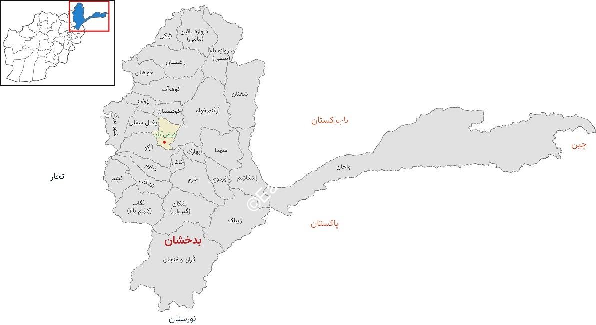
Badakhshan province is located in the northeast of Afghanistan and it is one of the mountainous and green provinces and shares a border with Tajikistan, Pakistan and China. In addition to having rich natural resources such as Lal and Lajurd mines, this province also has many ancient monuments that show its historical age.
Badakhshan province is located 470 km from Kabul, the capital of Afghanistan, and borders Kunar, Laghman and Kapisa provinces from the south and Takhar province from the west.
Where is Badakhshan province of Afghanistan and what is its importance?
Badakhshan is located in a mountainous region and includes high snow-covered mountains, such as the Wakhan Mountains, the Pamir Mountains, and the Hindu Kush Mountains; According to the climate, Badakhshan is hot in summer and very cold in winter, and in some of its areas, roads are blocked for six months a year due to heavy snowfall.
Badakhshan is 1,800 meters above sea level and its center is the city of Faiz Abad. The area of Badakhshan is more than 470 thousand square kilometers and it has a population of one million and 400 thousand people.
The majority of the residents of Badakhshan Province are Tajiks and they speak Persian. Some of the people of this province speak Pamir, Sheghani, and some residents on the border with China also speak Chinese. The majority of people in Badakhshan follow the Sunni Hanafi religion and another number follow the Shia Ismaili religion.
From the roof of the world to the tomb of Nasser Khosrow
According to administrative distribution, Badakhshan has 28 villages (city); These districts include Wakhan, Keshem, Baharak, Jurem, Yaftal, Raghistan, Ergo, Daraim, Arghanjkhah, Nesi, Shekai, Mayimi, Ishkashem, Khash, Pekan, Kofab, Kohistan, Faizabad, Shegnan, Koran and Monjan, Shahr Bozor. Martyrs are Tagab, Tishkan, Warduj, Yamgan (Yomgan), Yavan and Zibak.
Where is Badakhshan province of Afghanistan and what is its importance?
Wakhan: Wakhan district is located in the east of Afghanistan’s Badakhshan province and has a population of 18,328,000. This district is also called “roof of the world” due to its high altitude above the sea level. In 2013, it was introduced as the second national park of Afghanistan. The largest natural glaciers of Afghanistan are located in this district, and animal husbandry and tourism are sources of income for people in Wakhan.
Keshm: Keshm district with a population of 106,870 people is located in the west of Badakhshan province of Afghanistan. This district is also known as Badakhshan Gate. Kesham district is very beautiful where rice is cultivated; This district has rich resources and economically it is at a better level than all the districts of Badakhshan. Keshm Sea is also located in this district.
Baharak: Baharak district (Baharistan), which is located in the center of Badakhshan Province, has a population of 45,000 people. In terms of transit, this district is one of the most important highways of the Silk Road. This district has special importance in terms of geographical, cultural and economic location. The occupation of the people of Bharak is agriculture, animal husbandry, small businesses, hotel management.
Juram: one of the districts of Badakhshan province of Afghanistan, which is located in its center, is called Juram; The population of this district, whose previous name was Golan, is nearly three thousand people. The highest peak of Hindu Kush with a height of 6,729 meters is located in Joram district.
Yaftal district: This district is one of the western districts of Badakhshan Province, which has a population of nearly 88 thousand people. This district consisted of upper and lower parts, upper part of which was joined to the capital of Badakhshan province, Faizabad city, and only the lower part remained, which is the current part of Iftal district. The work of the people of this district is animal husbandry, agriculture and goldsmithing. The climate of this region is very suitable for growing some fruits such as berries, pistachios, apples, cherries, and cherries.
Taggs :
Afghanistan JOBS , Download Also this book , Articles ,+Publish your Books
Reviews
There are no reviews yet.