
About ((Ghor Districts Maps) دبلخ غور او ولسوالیو نقشه ): You can read short details of the book above. If You want to get the book ((Ghor Districts Maps) دبلخ غور او ولسوالیو نقشه ), than just click on DOWNLOAD Now Bottom, wait and the download will start to your Mobile/PC.
Quotes
Ghor; A beautiful and historical province in the center of Afghanistan
Ghor, which was in the administrative framework of Herat province, was formed as a separate province in 1342 and Chaghcharan city was designated as its center. In 2013, at the request of Ghor’s culture and youth and with the cooperation of the Department of Information and Culture, the center of this province was changed from Chaghcheran to Firouzkoh.
In terms of climate, it can be said that most of the regions of Ghor province are made up of mountains and cold weather prevails in many regions. So that in some areas of Ghor Province, with the beginning of autumn and winter season and heavy snowfall, the roads are closed for several months.
Ghor; A beautiful and historical province in the center of Afghanistan, Ghor; A beautiful and historical province in the center of Afghanistan, Ghor; A beautiful and historical province in the center of Afghanistan, Ghor; A beautiful and historical province in the center of Afghanistan, Ghor; A beautiful and historical province in the center of Afghanistan
But there are areas with moderate and hot climate in some parts of this province. The existence of three rivers Harirud, Farah Rud and Marghab in Ghor province has added to the beauty of this province.
Firouzkoh city, the capital of Ghor province, is located on the banks of the Harirud river, which is about 380 km away from Herat city. One of the reasons for the importance of this city is that it was the center of the Ghorian dynasty for about a hundred years.
The majority of the residents of Ghor province speak Dari language, and besides that, the people of “Lal and Sarjangal”, which is neighboring Bamyan province, speak Hazara language.
Before examining the latest security developments in Ghor province, we will get to know the geographical location and historical monuments of this region.
From Ghorian to Manar Jam
Before the 12th century, this area was home to Buddhists, Zoroastrians and a small number of Jews. The remains of the oldest settlements discovered by archaeologists between 2007 and 2008 in Ghor show evidence of life and civilization in 5000 BC.
The ruins of several castles and other defense fortifications were also discovered in the outskirts of Firuzkoh. The hand-carved Buddhist monasteries on the banks of the Haririud River indicate that they were built in the first centuries during the Buddhist era. These artificial caves show the testimony of the daily life of Buddhist monks in Ghor region.
Ghor was the capital of the Ghorian dynasty in the 12th and 13th centuries; “Manar Jam” is one of the remnants of that time. Jam Minar is located in the mountainous areas of Ghor province, 62 km northeast of Shahrek district (city) in the village called “Jam”, the place where the Jam river flows from south to north to the roaring river “Harirud” and at the confluence of these two rivers. contract.
Ghor; A beautiful and historical province in the center of Afghanistan, Ghor; A beautiful and historical province in the center of Afghanistan, Ghor; A beautiful and historical province in the center of Afghanistan, Ghor; A beautiful and historical province in the center of Afghanistan, Ghor; A beautiful and historical province in the center of Afghanistan, Ghor; A beautiful and historical province in the center of Afghanistan, Ghor; A beautiful and historical province in the center of Afghanistan, Ghor; A beautiful and historical province in the center of Afghanistan
This minaret was built in the 12th century and is 65 meters high. This building is the tallest clay minaret in the world after Qutb Minar in New Delhi, India.
On June 27, 2002, the United Nations Educational, Scientific and Cultural Organization (UNESCO) added the Jam Minar to the World Cultural Heritage List. UNESCO has announced that this great minaret is eroding due to the flow of water in the river near Jam minaret.
Minaret Jam has eight sides; Its sides together form a page that contains writings.
Among the other ancient areas of this province, we can mention the old Keshk area in Daulatyar district, which reflects the Buddhist era, and also the Dahhak Castle, which is located on the outskirts of Chaghacharan city (Firouzkoh), which dates back to seven thousand years ago.
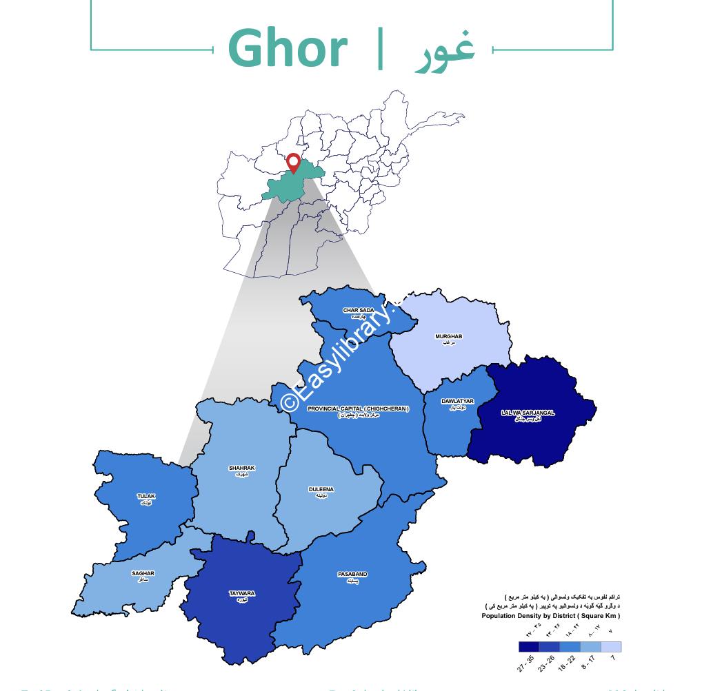
from Firouzkoh to Marghab; Ghor districts
Firozkoh: Firozkoh district is the largest district of Ghor province with 11,764 square kilometers. The population of Firouzkoh in 2020 has been announced as 166,236 people.
Ghor; A beautiful and historical province in the center of Afghanistan
Different ethnic groups live in Firouzkoh, mainly Hazaras and Imaghs constitute the majority of its residents. Other ethnic groups such as Tajiks and Pashtun and Turkmen minorities are also present in it.
Pasaband: Pasaband district has a common border with Helmand and Daikundi provinces and consists of 236 villages.
Tulak: This district has a common border with Herat province and has 212 villages. The language of the people of Tulak district is Dari, and Tajik, Pashtun, Hazara and Baloch people also live in this district.
Marghab: Marghab district is located 130 kilometers north of the center of Ghor province. At the request of the people, this area was established as a new district in 2018 by Ashraf Ghani, the president of the Republic of Afghanistan, with the center of “Shurabah”.
The most powerful party in Marghab is Jamiat Islami Afghanistan.
Tiureh: This district was once the center of Ghor Province, which was also called Ghor. The center of this district is called Ghor Castle, which has a common border with Parkhman district of Farah province.
Daulat Yar: Daulat Yar district has a strategic location and the central highway of East and West Afghanistan passes through it.
Dolina: This district is one of the cold regions of Ghor, which has 130 villages.
Charsadeh: Charsadeh district is in the north of Firouzkoh and has a common border with Faryab province, and Marghab river also passes through this district. Charsadeh is the largest Tajik district in Ghor.
Sagar: Sagar district is one of the greenest districts and has 115 villages.
Shahrek: Shahrek district is the same as Firuzkoh Sardsir, which is located at a distance of 2325 meters from the sea level. and Sarjangal: this district has a common border with Bamyan, Daikundi and Sarpol provinces. Lal and Sarjangal are among the most remote districts of Ghor. Lal and Sarjangal district consists of several large districts (Kerman, Garmab, Seng Zard, Joqal, Siah Seng Jalsu, Talhak).
Taggs :
Afghanistan JOBS , Download Also this book , Articles ,+Publish your Books
Reviews
There are no reviews yet.