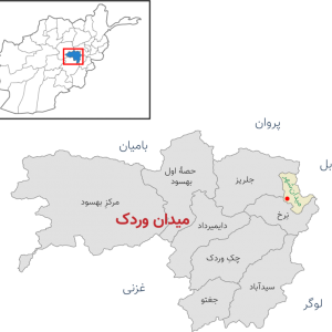
About ((Oruzgan Districts Maps) د ارزګان ولایت او ولسوالیو نقشه ): You can read short details of the book above. If You want to get the book ((Oruzgan Districts Maps) د ارزګان ولایت او ولسوالیو نقشه ), than just click on DOWNLOAD Now Bottom, wait and the download will start to your Mobile/PC.
Quotes
Where is Uruzgan province of Afghanistan and what is its importance?
Uruzgan; A province in the center of Afghanistan
Uruzgan is one of the 34 provinces of Afghanistan, centered on the city of Trinkot, which has a population of 436,79 people according to the census of 2019. The majority of the population of this province are Hazaras, and Pashtuns and Tajiks are also among its residents.
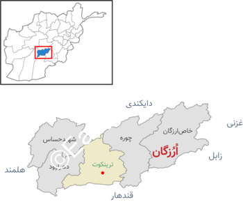
Uruzgan province is bordered by Daikundi province in the north, Zabul and Kandahar provinces in the south, Ghazni province in the east, and Helmand province in the west.
Kafir Castle, Dasht Nuji, Ant Castle, Pik Castle, Red Castle, Kotel Sabz, Gandab Castle, Siah Chore Spring, Khalj Gizab Valley, Takht Suleiman are part of ancient monuments of Uruzgan province of Afghanistan.
Uruzgan province of Afghanistan has 6 villages (city) named Trinkot, Chora, Khas Uruzgan, Dehrawood, Shahid Hassas and Gizab; Khas district is the largest and Dehrawood district is the smallest district of Uruzgan.
Where is Uruzgan province of Afghanistan and what is its importance?
Uruzgan districts; From Trinkot to Uruzgan Khas
Trinkot: Trinkot is the capital of Uruzgan province, which is located in the center of this province and has a population of 10,000. Trinkot has vast agricultural lands. The height of this city is 2,500 meters above sea level and its area is 12,640 square kilometers, which is approximately one fifty-first or 2.02% of the total area of Afghanistan.
Dehrawood: Dehrawood city is located 35 kilometers west of Trinkot and has more than 78 thousand people. This city has vast agricultural lands and green gardens, the Hirmand River also passes through Dehravud and irrigates the agricultural lands of this region. Wheat, corn and rice are cultivated in this city.
Choure: Choure city with nearly three thousand population is located 35 kilometers northeast of Trinkot. The occupation of most of the residents of this district is agriculture and animal husbandry. Choreh city is covered with forest, which has given it a lot of beauty. There are many historical areas in this district, including Tore Chini, Karvan Ghondi and Nikeh Jan Ziarat.
Shahid Hassah (Charchino): This district is located about 60 kilometers northwest of Trinkot and has a population of nearly 84,000. The residents of this district are engaged in agriculture like other districts and the most important products are wheat and corn.
Gizab: This district is located about 70 km north of Trinkot, Gizab has orchards and Hirmand river passes through its center, most of its people are engaged in agriculture and animal husbandry.
Uruzgan Khas: This district is located 90 kilometers northeast of Trinkot and its population is nearly 84 thousand people. The weather in Uruzgan Khas is colder than other districts of Uruzgan. Pashtuns and Hazaras live in this district.
Where is Uruzgan province of Afghanistan and what is its importance?
Uruzgan; A province with an age of more than 1500 years
The discovery of Greek inscriptions in Uruzgan written around 500 AD tells about the historical past of this region. Ahmad Ali Kohzad writes in the book “Afghanistan in the Light of History” that Uruzgan is a small inter-riverine mountain that is covered by two large rivers and floods in the north and south, namely Hirmand and Arghandab, and the history of Uruzgan dates back to 500 AD.
An English archaeologist named Bivar found two stone inscriptions in 1331 AD, 241 km northwest of Kandahar. On the first inscription, the Greek word “Yaftli” was engraved in Greek script, and on the second inscription, the names “Zabel” and “Mihibrakula” and the words “Bagh” and “Shah” were engraved as “Baghu” and “Shavu”. These two words are god and king, and Kanishkai Kushan was called “Lord of the King”. This shows that King Yaftali called himself “Lord” and “King” in the way of his predecessors.
Where is Uruzgan province of Afghanistan and what is its importance?
Before the Islamic period, Uruzgan was the center of Zabulistan and was ruled by a powerful king named Zavel Shah (Zanbilshah or Ratbilshah). In the Islamic periods, especially during the Ghaznavid period, this region was important and was the concern of the rulers. After the Ghaznavids, Uruzgan was ruled by the Ghorians, the Khwarazmshahs, the Al-Kurts, the Timurids, the Hotaks, and the Durrani Empire. The authority and importance of Uruzgan continued until it emerged as a powerful and independent local government, and from the time of Nader Shah Afshar to the period of Abdul Rahman, it was considered one of the most important and large provinces of Hazaristan. Abdur Rahman did a lot of damage to the Hazara people of this region with attacks and usurped most of the Hazara areas of Uruzgan.
Later, Pashtun and Hazara parties entered Uruzgan and took over the administration of the region, and until 1367, relatively normal relations were maintained between them. In 1369, a war between Pashtuns and Hazaras took place in the region, which is known as the Uruzgan War of 1369. In 1373, the Taliban group, after advancing in other regions of Afghanistan, easily captured the Pashtun-inhabited areas of Uruzgan and brought them together. Then he entered into negotiations with the Hazara parties and over time took control of the Hazara areas, but after that he started suppressing the Hazara people.
Taggs :
Afghanistan JOBS , Download Also this book , Articles ,+Publish your Books


Reviews
There are no reviews yet.