About ((Parwan Districts Maps) د پروان ولایت او ولسوالیو نقشه ): You can read short details of the book above. If You want to get the book ((Parwan Districts Maps) د پروان ولایت او ولسوالیو نقشه ), than just click on DOWNLOAD Now Bottom, wait and the download will start to your Mobile/PC.
Quotes
Historical province of Parwan, Afghanistan; From the past to the present
Parvan; A historical province in eastern Afghanistan
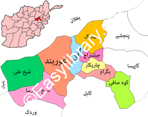
Parwan province of Afghanistan, which is located in the east of this country, has a significant history. Parwan province shares borders with Baghlan province from the north, Kapisa and Panjshir provinces from the east, Kabul and Maidan Wardak provinces from the south, and Bamyan province from the west.
Charikar city is the center of Parwan province, which is located 64 km from Kabul. This province has an area of 5,974,000 square kilometers, and its population in 2019 is about 737,700 people. The eastern regions of Parwan province have more development and facilities due to their location on the highway from Kabul to Mazar-e-Sharif and proximity to the capital.
This province, which has gold, marble, coal, copper and lead mines, has 10 districts named Bagram, Ghorband, Koh Safi, Saidkhel, Sheikh Ali, Charikar, Jabalseraj, Salang, Sarkh Parsa and Shinwari.
Historical province of Parwan, Afghanistan; From the past to the present
From Bagh God to Mount Safi
Bagram: One of the districts of Parwan province is Bagram district, which has a population of over 117,000 people. This district is bordered by Kabul province from the south, Shinwari district from the east, and Charikar district from the north.
Bagram is composed of two words “Bagh” and “Ram” meaning “Garden of Ram” or “Garden of God”; Historians believe that human habitation in Bagram dates back to our time before history; This district has been extremely important throughout history due to its location on the Silk Road and its green and watery nature.
Bagram district has become a military center in the last forty years. After the events of September 11, 2001 in the United States and the collapse of the twin towers of the World Trade Center in New York, the Bagram military airfield was captured by the American invaders.
After the events of September 11, the American government arrested 6 thousand people and imprisoned them in Guantanamo and Bagram prisons. In the first ten years of the US invasion of Afghanistan, about 3100 people were arrested and the US transferred all the prisoners from Guantanamo to Bagram, Afghanistan. In addition to Afghan prisoners, there were also people from Arab countries, Pakistan and Libya in this prison.
Ghorband: Ghorband is one of the historic districts of Parwan province. Ghorband, which means “mountain barrier on the way to Ghor”, is located on the southern slopes of the Hindu Kush. Ghorband has a population of over 109,000 people and is bordered by Kabul province from the south, Shinwari district from the west, Sarkh Parsa and Sheikh Ali districts from the east, and Baghlan province from the north. The main products of this district are almonds, apples, apricots, berries, grapes, peaches and other similar fruits.
Saidkhel: Saidkhel district is one of the districts of Parwan province. Sidkhel, which is located on the southern slopes of the Hindu Kush, has an area of 560 square kilometers. The population of Saidkhel in 1399 was announced as more than 51 thousand people. This district is bordered by Bagram district in the south, Kapisa province in the east, Charikar district in the west, and Jabal Siraj district in the north.
Charikar: Charikar district is the center of Parwan province and one of the most populated cities in Afghanistan. The population of this district is more than 202 thousand people; Charikar is located about 64 kilometers north of Kabul, and the main road from Kabul to Baghlan, as well as northern Afghanistan, passes through Charikar. The area between Kabul and Charikar is the most densely populated area in Afghanistan. The industry of linen cloth, making knives and metal tools of Charikar and its surroundings is very famous in Afghanistan.
Historical province of Parwan, Afghanistan; From the past to the present
Jabal Siraj: One of the districts of Parwan Province is Jabal Siraj; This district is one of the industrial districts of Afghanistan and has a population of about 72 thousand people. Jabalsaraj, which is located on the southern slopes of the Hindu Kush, has an area of 173 square kilometers. The first textile factory in Afghanistan named Golbahar Textile Factory was built in 1332 in Jabal Siraj district. At that time, about 15 thousand workers were working in this factory. After the civil wars in Afghanistan, the activity of this textile factory was stopped and it started its activity again in 2015.
Salang: Salang district is one of the districts of Parwan province, which is located on the southern slopes of Hindu Kush and has an area of 560 square kilometers. The population of Salang is estimated at more than 29 thousand people. Salang district has significant marble mines. The first and largest tunnel in Afghanistan is the Salang tunnel, which is two kilometers and 700 meters long, and connects the north of the Hindu Kush mountain to its south. With the construction of this tunnel, the road connecting the north of Afghanistan to the south was shortened by 110 km.
Sarkh Parsa: one of the Hazara districts of Parwan province is Sarkh Parsa district; This district has an area of 859 square kilometers and its population is about 46 thousand people. This district is bordered by Kabul province from the south, Ghorband district from the northeast, Bamyan province from the west, and Sheikh Ali district from the north.
Sheikh Ali: One of the Hazara districts of Parwan province is Sheikh Ali district. This district is the border between two provinces of Bamyan and Parwan, and the main Bamyan-Parwan highway passes through Sheikh Ali. This district, which is one of the busiest areas in the summer season, has an area of 859 square kilometers. The population of Sheikh Ali is about 28,000 people, and this district is bordered by Sarkhparsa district from the south, Ghorband district from the east, Bamyan province from the west, and Baghlan province from the north. The people of Sheikh Ali are Hazara people and most of them are engaged in gardening and agriculture; Apples, apricots and almonds are the most important products of this district.
Afghanistan JOBS , Download Also this book , Articles ,+Publish your Books


Reviews
There are no reviews yet.